At a Glance:
Offshore wind turbines will be visible if they are closer than 40 miles away. But how visible? A picture is worth a thousand words - take a look at the images below simulating the wind turbines’ appearance from various points on the Rhode Island shore for the Revolution Wind Farm, the project that will be closest to the New England shore, about 15 miles away from some parts of RI. The images are visual resources provided by the wind farm developer, Orsted, to the Bureau of Ocean Energy Management (BOEM) for the final Environmental Impact Statement for Revolution Wind. Other wind farms are further from shore including the Mayflower Project's wind turbines that will be about 30 miles south of Nantucket.
Note that Figures 1-3 simulate the “worst case scenario”, the appearance of the originally planned 100 wind turbines on high visibility days (>10 miles) of the largest wind turbines planned for use. Considering the decrease in numbers of turbines now actually approved and also depending on weather and atmospheric conditions they would often be less visible. It is estimated that visibility to 23 miles occurs during approximately 31 percent of the year.
Note that the originals should be viewed from the report and website linked above on a 24-inch computer monitor from a distance of 30 inches.
Figure 1. View from the Newport Cliff Walk of simulation of wind turbines from the Revolution Wind Farm.
Figure 2. View From Hanging Rock, Norman Bird Sanctuary, Middletown, RI of simulation of wind turbines from the Revolution Wind Farm.
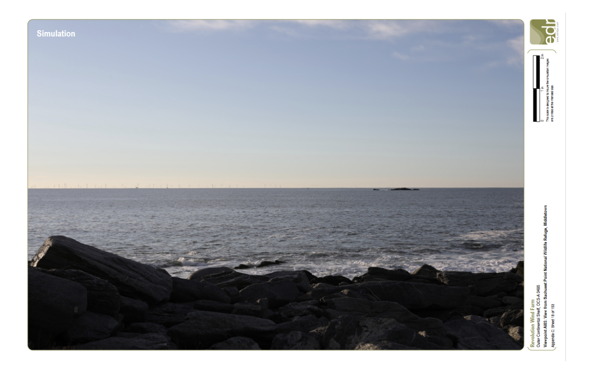
Figure 3. View From Sachuest Park National Wildlife Refuge, Middletown, RI, of simulation of wind turbines from the Revolution Wind Farm which is 14.9 miles away.
Video simulations offer an even clearer sense of the visibility of the wind turbines throughout both day and nighttime on a day with greater than 10 miles of visibility. For example, from Sachuest Point in Newport County, RI the video illustrates changing visibility of the Revolution Wind Project of 98 wind turbines with the maximum wind turbine generator size under consideration, a blade tip height of 873 feet. The distance to the project is 14.9 miles.
A second video from a closer vantage point of 13.6 miles from the Revolution Wind project, Moshup Beach, Dukes County, MA
To reduce nighttime visibility Revolution Wind plans to use an aircraft lighting detection system (ADLS) that only turns on when an aircraft is approaching. This would reduce the amount of time the lights are visible at night to as little as three hours per year.
The original images of the copies below can be viewed on Revolution Wind’s report . More original images are on the BOEM website
A Deeper Dive:
The methods used by Orsted for their viewshed analyses of Revolution Wind are consistent with methodologies developed by various state and federal agencies, including the Bureau of Land Management, the National Forest Service, the US Department of Transportation Federal Highway Administration, and other federal agencies according to the Technical Report – Visual Impact Assessment, Revolution Wind Farm. This document includes discussion of how atmospheric conditions and weather impact the visibility of the turbines from shore. “The BOEM meteorological report completed in 2017 for the MA/RI Lease Areas, suggests that visibility of the Revolution Wind project will likely be limited under certain atmospheric conditions. For example, from Martha’s Vineyard, daytime visibility reaching 23.0 miles occurred over 113 days (31 percent of the year) and visibility to 34.5 miles occurred during 32 days of a given year (8.8 percent of the year). For viewing location in which the Revolution Wind project is 20 nautical miles (23.0 miles) or greater from shore, the wind turbines would not be visible for the majority of a given year.”
What Will the Turbines Look Like From Shore?